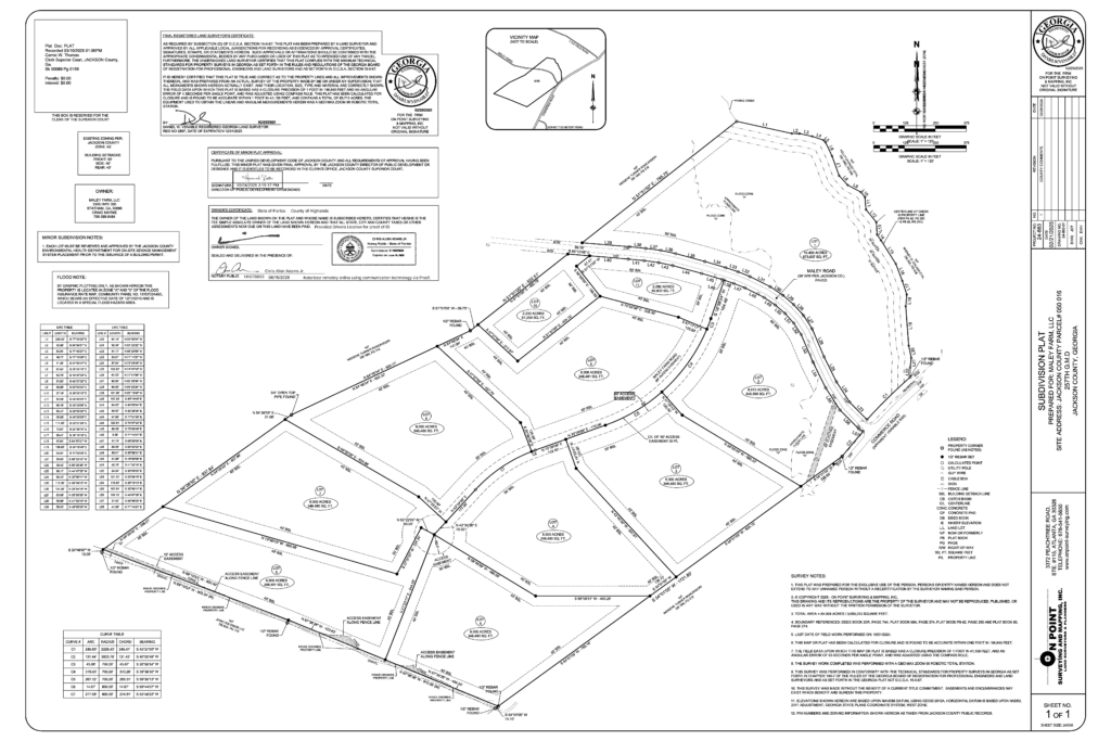
A recorded plat can tell you a remarkable amount about a piece of land before you ever set foot on it.
It is a surveyed drawing filed with the county as part of the public record. Depending on the property and the type of plat, it may show boundary lines, surveyed acreage, road frontage, access, easements, rights of way, adjoining parcels and the monuments marking the corners.
Read it in the right order and, within a few minutes, you can understand the shape of the property, how it is reached, what rights may affect it and which questions to ask before walking it.
What is a recorded plat?
A recorded plat is a survey drawing that has been filed in the county’s official plat records.
In Georgia, recorded plats can often be located using the county, plat book and page number or other indexed information. The Georgia Superior Court Clerks’ Cooperative Authority also provides a statewide Plat Index for locating recorded plats and maps.
A plat may include:
- The parcel’s surveyed boundaries
- Bearings and distances for boundary lines
- Calculated acreage
- Roads and frontage
- Easements and rights of way
- Adjoining property owners or parcels
- Survey monuments found or set
- Recording references
- Survey date
- Notes from the surveyor
The exact information varies, which is why every label, note and reference deserves attention.
A recorded plat should be reviewed alongside the deed, title work and current property information. Each document serves a different purpose, and together they provide a fuller picture of the land.
A plat is the drawing. A boundary survey is the work behind it.
These terms are often used interchangeably, even though they describe different parts of the process.
A boundary survey is the professional work completed to locate and evaluate the property boundaries. A Georgia land surveyor reviews deeds, adjacent property descriptions, rights of way, existing maps and other available boundary evidence. The surveyor then completes the necessary fieldwork, measurements and analysis.
Georgia’s technical standards for property surveys establish requirements for that work, including survey monuments and the information shown on maps and plats.
The plat is the drawing produced from the survey.
When that drawing is filed in the county’s plat records, it becomes a recorded plat that can be located and reviewed as part of the public record.
The distinction matters. A survey may have been completed without the resulting plat being recorded. A recorded plat carries filing information that allows buyers, surveyors, attorneys, lenders and county offices to locate the document later.
How to read a recorded plat in five minutes
A plat can appear complicated at first because it combines measurements, symbols, notes and legal references on one page.
Use this reading order:
- Confirm that you have the correct property.
- Find the road and determine how the parcel is accessed.
- Trace the entire boundary.
- Identify easements and rights of way.
- Review the surveyed acreage.
- Locate the corner monuments.
- Read every note and recording reference.
- Compare the plat with the deed and current property information.
This sequence takes you from the most practical question, “How do I reach the property?” to the finer details that may influence how the land can be used.
First, confirm that you have the correct plat
Before studying any lines or measurements, read the title block.
Look for:
- Property or subdivision name
- County
- Land lot and district, when applicable
- Owner or client named on the survey
- Survey date
- Surveyor’s name and seal
- Plat book and page or other recording information
- Parcel or lot designation
This step matters when a larger property has been divided, several lots have similar names or an older plat has been replaced by a newer one.
Confirm that the lot number, acreage and surrounding roads match the property you are considering.
Read the access next
Access can shape how a property feels to live on, where a driveway can go and how easily utilities or construction vehicles can reach the homesite.
Start by locating the road shown on the plat. Then determine whether the parcel borders that road directly or relies on an access easement across another property.
Road frontage
Road frontage means the property touches the road shown on the plat.
The plat may also show the road’s right of way. It does not automatically establish who maintains the road. A road may be maintained by a county, municipality, the state, a private owner or the people who use it.
Confirm the road type and maintenance responsibility separately.
Access easement
An access easement may give the property owner a legal right to cross land owned by someone else. It may also allow another property owner to cross part of the land you are considering.
The plat may show the easement’s location and width. The full terms may appear in a separate recorded document referenced on the plat or in the title work.
Public-road frontage and access through an easement can both provide workable ways to reach rural land. The important thing is knowing which arrangement applies and understanding how it affects the driveway, utility planning, maintenance and future use.
Find every easement and right of way
An easement is a legal right to use a defined part of a property for a particular purpose.
It may benefit the land by providing access or utility rights. It may burden the land by allowing a utility provider, neighboring owner or another party to use part of it.
Common examples include:
- Access easements
- Utility easements
- Drainage easements
- Road rights of way
- Shared-driveway easements
- Conservation easements
Easements may be shown with dashed lines, solid lines, shaded areas or another symbol. Check the legend, labels and notes because drawing conventions vary.
Pay attention to:
- Purpose
- Width
- Location
- Recording reference
- Whether the easement benefits or crosses the property
- How it relates to the proposed homesite and driveway
An easement does not automatically make a property unsuitable. Its position may influence where a house, workshop, driveway or other improvement can be placed.
Finding it while you are still reading the plat gives you time to plan around it and ask for the underlying document when more detail is needed.
Review the surveyed acreage
Listing descriptions may use rounded acreage. A recorded plat commonly gives a more precise area calculated from the surveyed boundary shown on that document.
The plat may also distinguish between the total calculated area and portions affected by a road right of way, access strip or other feature.
If the listing, deed and plat show different acreage figures, ask why. Possible explanations include:
- The listing uses a rounded number
- The parcel was divided or recombined
- A newer plat replaced an older one
- The documents calculate or describe an access area differently
- The marketing information has not been updated
A difference is not automatically a warning sign. It is a question to resolve.
Use the surveyed acreage as an important reference and compare it with the deed, title work and most current recorded property information.
Trace the boundary lines
Follow the boundary around the entire parcel.
The lines may include bearings and distances showing the direction and length of each segment. Curved road frontage may include additional measurements, and creeks or other irregular features may be represented with survey or meander lines.
Tracing the boundary helps you understand:
- The property’s overall shape
- Where it narrows or widens
- How much road frontage it has
- Where neighboring parcels meet it
- Whether an access strip forms part of the parcel
- How the shape may affect the homesite and other uses
Two parcels with the same acreage can function very differently. A wide, compact parcel and a long, narrow parcel may create different options for privacy, driveway placement and future structures.
The acreage tells you how much land is included. The boundary shape begins to tell you how that acreage may live.
Locate the survey monuments
Survey monuments mark boundary corners on the ground. The plat should describe the monuments the surveyor found or set, such as capped metal rods, pins or other durable markers.
Georgia’s property-survey standards require boundary monuments to be described on the plat and establish minimum requirements for monuments set by surveyors.
These descriptions help you connect the drawing to the property during a land walk.
Look for abbreviations or notes near each corner. The plat legend may explain what they mean.
Millwood also marks property lines so buyers can more easily follow the surveyed boundary while walking the land. The survey monuments establish the corners, while the additional markings help make the lines between them easier to understand on the ground.
Read every note
Some of the most important information may appear in small print around the edge of the drawing.
Plat notes may address:
- Survey methods
- Sources used by the surveyor
- Easement references
- Road rights of way
- Flood-map information
- Setback lines
- Restrictions
- Monument descriptions
- Acreage calculations
- Previous plats
- Recording references
Do not rely on the drawing alone. Read the notes, legend and title block before deciding you understand the property.
A referenced deed book, plat book or instrument number may lead to another document containing terms that are not fully reproduced on the plat.
What a recorded plat will not tell you
A recorded plat describes surveyed boundaries and the features shown on the drawing. It does not provide a complete evaluation of the ground or determine every way the property may be used.
A plat generally will not confirm:
- Whether the soil supports a septic system
- Where a septic system should be placed
- How water moves across the property after heavy rain
- Whether every area is dry, level or usable
- What the county permits you to build
- Whether animals or a home-based business are allowed
- The cost of bringing utilities to a proposed structure
- The condition of a private road
- Whether the property fits your intended home
- Current title ownership
A perc test completed by a licensed soil scientist is separate from the boundary survey. Zoning and permitting information comes from the appropriate county offices. Drainage, slope and usable ground require additional documents, professional input and a physical property walk.
Some plats include contour lines, flood information, setback lines or proposed septic areas. Their presence does not turn the plat into a complete site-development plan. Confirm what each feature represents and whether more current information is available.
Can a recorded plat become outdated?
A recorded plat remains part of the public record, even when newer activity affects the property.
A later owner may divide or combine parcels. New easements may be recorded. Roads and neighboring properties may change. A newer survey may identify updated measurements or replace an earlier plat.
Check:
- The survey date
- The recording date
- References to previous plats
- Whether a later plat exists
- Whether the deed describes the same parcel
- Whether later easements or restrictions have been recorded
An older plat may still contain useful information. Confirm that it remains the most relevant drawing for the property you are evaluating.
Take the plat with you when you walk the land
Ask for the recorded plat before visiting the property.
Read the access, easements, acreage and notes first. Then carry the plat while you walk. Find the road frontage, identify the corners and follow the marked boundaries as closely as the terrain allows.
Ask yourself:
- Does the visible access match the drawing?
- Can I locate the marked corners?
- Do the property lines match what I expected?
- Where do the easements cross?
- How does the parcel’s shape feel on the ground?
- Which parts appear suitable for the homesite and future plans?
- What questions can only be answered by another document or professional?
This is the step that turns a technical drawing into practical knowledge.
If you cannot identify a corner or reconcile something on the plat with what you see, make a note and ask for clarification. The goal is not to interpret every survey symbol on your own. It is to arrive at the property with better questions.
Walk the property with better information
A recorded plat cannot tell you everything about a piece of land. It can give you a much clearer understanding of what has been surveyed, how the parcel is shaped, where it meets the road and which recorded features may influence your plans.
Read the access first. Find the easements. Confirm the acreage. Trace the boundaries. Read every note. Then take the drawing onto the land and compare the record with what you see.
At Millwood Land Company, every property we prepare has a boundary survey completed and property lines marked before it is offered for sale. We provide the recorded plat so buyers can review the land before they walk it and arrive with better questions.
We prepare land so you can buy and build with confidence.
Ready to understand the land before you choose it?
Explore Millwood’s current properties and review the survey, access, groundwork and property details available for each opportunity.
Still learning what to evaluate before buying rural acreage?